EarthBrowser
3.1.3 – Monitoring Real Climate Change!
Reviewed by Robert Pritchett
Introduction
EarthBrowser
is a real-time three-dimensional model of the earth with continuously updating
global information. It renders a virtual representation of the earth along with
a large variety of data which is accurate to the minute. The globe can be
easily rotated and magnified to give a distant or close up view of the earth
from space.
Lunar
Software does not guarantee availability or timely delivery of cloud or weather
data. EarthBrowser should not be used to support operational observation,
forecasting, emergency, or disaster mitigation operations, either public or
private.
What
I Learned
We
reviewed this app many years ago. Now it uses Adobe AIR, instead of QuickTime
and it really does update every minute in real time. It isn't just dynamic,
it's real-time fun and a great way to learn about the earth, especially if you
have Internet connectivity.
Matt
Giger says this is shareware, but if you like the app, buy it. You can try
before you buy.
The
software has been localized for 21 different languages from Arabic to Swedish.
There
really is the option for a 7-day forecast. Links really are live. There are 3
options for worldviewing, including Near Realtime Satellite, OpenStreet and the
original EarthBrowser modes.
The
menu compresses, but I like the translucent mode myself. I'm also impressed
with the Aurora activity and the Atmospheric Electron Content.
I
think being able to move the globe around from any direction is a real plus. So
is being able to zoom all the way in to street level. House level would have
been nicer.
Being
able to see Panoramios (GoogleEarth localized photos) and the webcams is sweet.
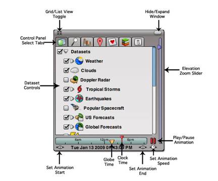
The
menu allows for drilling down even further by subsections. Earthquakes break
down to magnitudes that break down to locations and a 7-day history.
Mouse
over cities and the 7-day weather template shows up.
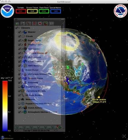
Go
to Tropical Storms, then track surface winds at different speeds. Click on
Storm Tracks and follow them by name.
Follow
the Flood warnings and watch the earth rotate to the locations and then pull up
the details from the National Weather Service.
If
you want to see real Climate Change, add the flags for Global Forecasts for
precipitation, temperature, atmospheric pressure, relative humidity, wind
direction, sea surface temperature and even the ozone
.
Interested
in seeing fires in Canada and the US?
Offworld,
are you interested in where the International Space station is located? How
about the Hubble Space telescope? Or weather satellites?
How
about underworld with tectonic plates and plate convergence?
Or
Volcanic activity active, dormant and extinct? Drill down to continent and
volcano.
Interested
in Webcams? Worldwide? Again, go to Continent, country, then live locations.
With
Adobe AIR, the detail got even finer. Almost photo-like.
This
app grows on you.
Conclusion
This is what
GoogleMaps should have been. This is looking at real, up-to-the-minute Climate
Change.
More
I added the free
EarthBrowser Site Tracker to the macCompanion and Alternative Energy User Group
websites.
"The
free EarthBrowser Site Tracker will show you where and when people visit your
site from all over the world. Watch each visit to your website expand into
space as night crosses the earth. Play your traffic back and forth with the
timeline slider, zoom in and out and see aggregated website stats that are
updated every 10 minutes."
<object
width="600" height="370"><param
name="movie"
value="http://api.earthbrowser.com/sitetracker/?siteid=cb756419e236276e284f2489df184d41&color=499A13&hours=24&maxcount=1000&showtime=true&showstats=true"/><param
name="allowscriptaccess" value="always"/><embed
src="http://api.earthbrowser.com/sitetracker/?siteid=cb756419e236276e284f2489df184d41&color=499A13&hours=24&maxcount=1000&showtime=true&showstats=true"
type="application/x-shockwave-flash"
allowscriptaccess="always" width="600"
height="370"></embed></object>